Why and where high-severity fire occurs

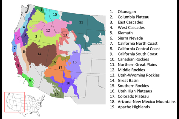
Wildland fire is a critical process in forests of the western United States (US). Variation in fire behavior, which is heavily influenced by fuel loading, terrain, weather, and vegetation type, leads to heterogeneity in fire severity across landscapes and even within individual fires. Sean Parks from the Aldo Leopold Wilderness Research Institute, along with colleagues from the Rocky Mountain Research Station and the University of Montana, explored the drivers of high severity fire in forested ecoregions in the western US over the period of 2002-2015.
Parks and his colleagues found that live fuel, on average, was the most important factor driving high-severity fire among ecoregions (average relative influence = 53.1%) and was the most important factor in 14 of 19 ecoregions. Fire weather was the second most important factor among ecoregions (average relative influence = 22.9%) and was the most important factor in five ecoregions. Climate (13.7%) and topography (10.3%) were less influential.
The models in this study were used to produce gridded maps depicting the probability of high-severity fire for several regions in the western US. These maps can help land managers identify areas where high-severity fire is most likely to occur. All maps use fuel data representing the year 2016 and therefore provide a fairly up-to-date assessment of the potential for high-severity fire. For those ecoregions in which the relative influence of fire weather was fairly strong, two additional maps were produced, one depicting the probability of high-severity fire under moderate weather and the other under extreme weather. These maps will be useful for both wilderness and non-wilderness managers.
Maps are downloadable from FRAMES.
Contact Information:
Sean Parks
Aldo Leopold Wilderness Research Institute
Rocky Mountain Research Station
US Forest Service
sean_parks@fs.fed.us
Full Publication:
Parks SA, Holsinger LM, Panunto MH, Jolly WM, Dobrowski SZ, and Dillon GK. 2018. High-severity fire: evaluating its key drivers and mapping its probability across western US forests. Environmental Research Letters. 13: 044037.